BUT, it also marks the beginning of the bears land, the hard mountain passes and long stretches without a good rest...
I was happy to leave south California behind, yet I was scared from what we were about to start.
For keeping away the bears from our food we had to (by law) to carry all the food inside a bear canister, which weights more than a KG. So, not only we carried 6 days food, we also had to carry this huge plastic can. It takes the entire space in my backpack and I can say it was hate from first sight.
From the moment we left Kennedy, you could tell the difference. Everything is green, water is everywhere.


We passed a burned forest hopefully for the last time...

I was very optimistic about water crossing after seeing bridges everywhere...

After couple of hours we reached our first Sierra snow. The sight was beautiful.


The hike was hard though... Lots of miles, lots of climbs. We always stayed between 9,000 feet to 11,500 feet. It's not easy... You can feel your heart beats like crazy.


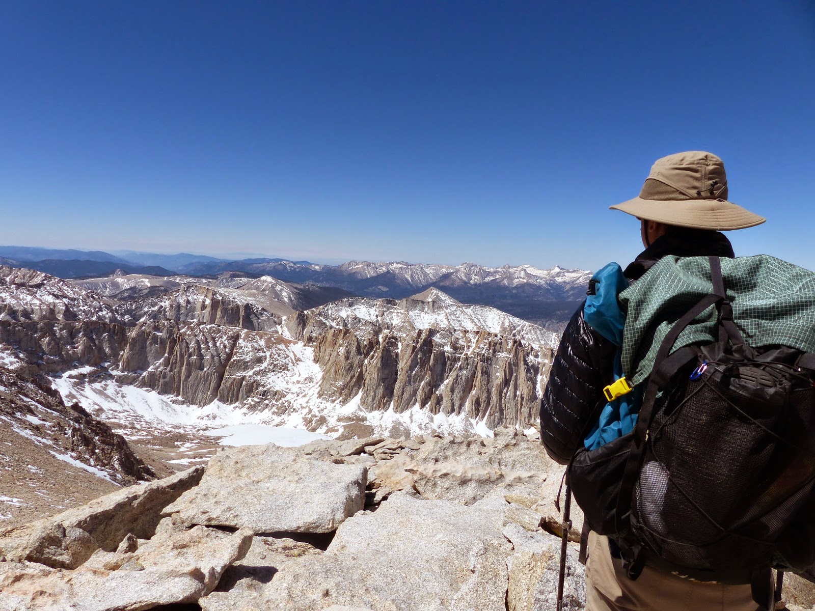
On our third day we hiked towards Mt. Whitney, the highest mountain it the US (excluding Alaska) - 14,500 feet. It felt like walking in a dream. Water everywhere, animals running on the fields, big snowy mountains...


We camped next to a lake called Guitar lake, which was partially frozen, at the foot of mt Whitney.

Apparently, the real enemy here are not the bears, but the marmots... They tend to really like chewing hikers gear, everything, including trekking poles and anything that looks interesting for them...


The next morning we started the long climb... Snow was evertwhere, but only in small sections each time. The real challange was the ice. It was super cold early in that morning and ice was covering the trail in some sections, making it almost impossible to cross.
I'm not sure how, but we made it finally to the peak :)
It was worth every snow and ice on the way. A dream...


By the time we went back down to our tent, the ice disappeared and the hike was better and easier.
After going back to our tent (we left it behind so we won't need to carry it to the summit) and eating out lunch we kept hiking towrds our next challenge - Forester pass, the steepest ang highest (13,200 feet) pass on the PCT and also the highest point on the trail.

We camped 5 miles before it, after crossing few strong streams and getting completely wet... (No bridges here...).


We woke up to a freezing morning with a little bit of ice covering our tent.
As we got closer to the pass we saw more and more snow. Beautiful, did I mentioned that already?


Once we got to the final climb, we couldn't see the trail, everything was covered in snow. So we just climbed straight up to a higher point where the trail seemed to appear again.
The last part of the climb was easy and fast and next thing we knew, we were standing on the pass. Looking to the other side, we were amazed to find out there's a lot more snow there...

We started going down, walking on the snow. On the first hour it was fun, different... Then, at late noon, the snow became softer, the trail was still well hidden beneath it. We lost the trail so many times and started sinking into the snow with every step. It was hard, endless. We walked like that for more than an hour... Until the trail was seen again...
Apparently snow can be a dangerous thing. This is my new enemy now :)


We camped next to the exit point of the trail, from where we needed to hike 8 miles more to get to a road where we can hitch to a nearby town.

Next morning was freezing. Our shoes were still wet from yesterday's snow and the streams crossings. It was a real challenge to get into the shoes...

We had to cross one more pass on the way. This time the snow wasn't so bad... But after we reached the pass we went down and down for more than 2000 feet. We will need to climb all this back in few days :( But we should not think about this now...


It took us 2 hours to get a ride from the trailhead to the closest town, Independence. From there we hitched again to another town, bigger one, Bishop, where we are now, enjoying 2 zeros... :)
No comments:
Post a Comment